Interview with Sophie E Tallis, Map Designer.
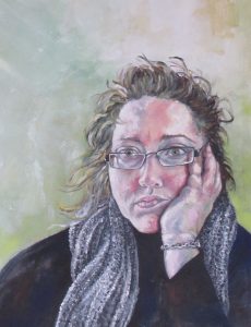
Self Portrait oil on canvas Sophie E Tallis
Sophie E Tallis is an illustrator, artist and author from Bristol. Her illustrated novel, epic fantasy, White Mountain, was published by BFS Award winning publisher, Grimbold Books, who also published the acclaimed anthology, Fight Like A Girl, which features one of her short stories, Silent Running.
Grimbold Books has also published two White Mountain related short novellas, A Friendship Forged and The Siege of Kallorm in ebook form. Sophie has been a practising fine artist for over 20 years and a professional freelance illustrator for the last 10 years working for HarperCollins and Penguin Random House among others and has been an Artist-in-Residence for Oxford University. Sophie has also been shortlisted for the 2018 and 2019 British Fantasy Awards (BFS) in the Best Artist category.
Illustration Website: Sophie E Tallis Illustrations
Etsy Shop: Sophie’s Artisan Arts
Book: thedarklingchronicles
FB page: facebook/fantasyepic
Blog: Sophie E Tallis Blog
Welcome to the Hive Sophie, we are thrilled to have you here!
It’s lovely to be here!
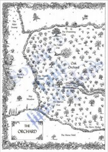
Orchard: A Year in England’s Eden by Benedict Macdonald & Nick Gates
Firstly, could you tell us about a few of the maps you have worked on recently please?
I’ll chat about completed ones as I never discuss current projects, the last thing an illustrator wants to do is reveal something the author or publisher doesn’t want revealed yet and steal their thunder, so I’m good at keeping schtum!
One project I worked on last year that was completely different to the fantasy maps I usually do, was a map for a non-fiction book called ‘Orchard: A Year in England’s Eden’, published by HarperCollins in August 2020. It was written by two amazing wildlife filmmakers, Benedict Macdonald & Nick Gates, who have worked for David Attenborough programmes, Springwatch, Discovery Channel documentaries etc. They’d spent a year observing the wildlife, eco-systems and habitats of an old orchard, recording every aspect of the rich biodiversity there and the rare species it supported compared to most modern day orchards which are utterly devoid of wildlife. It ended up being a really personal project for me, a mix of art and my own passion for environmentalism. I’m thrilled to say that the book recently won a prestigious literary award as well, as best nature book of 2020!
Could you tell us a little bit about your process? Typically, how do you get from your initial ideas to the stages of the final map design? Do you have a routine when starting a project?
The way I like to work, which is different from most illustrators, is that I like to be very collaborative with the author/publisher. I tend to send them 1001 questions to start with, often posing questions they hadn’t thought about. Sometimes that means corresponding back and forth directly with the author, which I prefer, but sometimes (with publishers like Penguin & Random House) you have to correspond through a third party like an editor, art director or creative head, so the communication process can take longer.
This does several things, firstly it opens up a great creative conversation between me and the creator of the world I’ll be recreating, but it also gives me a much clearer idea of what they want so I can deliver an end map/product which they are 100% happy with. Usually with book illustration, the illustrator simply does the artwork and the first time the author/publisher sees it is when it’s finished and done, so there’s no opportunity for them to add or change any aspects. That is standard industry practice so the way I work is definitely unique.
Apart from asking specific questions about the map itself, geography, geology, topographical features regarding rivers, coastlines, mountain ranges, estuaries etc., I give the client a choice of fonts to choose from for the labelling, I send them designs for the title box, the border design and compass if there is one. One of my signature things is that I always do an individual compass design for every client and map, so they are completely unique to that project. These compass designs usually reflect/embody an aspect or theme of the book. Once I have the detailed information I need, I then formulate my rough sketches & designs. I send these designs to the client and again we work back and forth to refine or change things until they are happy, then I start on the final work.
Do they give you rough sketches, or is it usually brief descriptions of what they are looking for?
Initially I’ll ask for a rough sketch, just something I can see to get an idea of what they want, but really the most vital part of the process for me is the asking questions, where I really drill down into the detail of the world they want me to recreate. No detail is too small. However, some publishers have a more reserved approach. HarperCollins have been surprisingly open to me communicating directly with authors back and forth to get the maps exactly how the authors want, they’ve admitted several times that this is unusual, but some of the US based publishers like Penguin Random House were more reserved and I had no direct contact with the authors so everything had to be relayed through a team of people. In cases like that, I’m often pitching ideas to them more rather than waiting for instructions back. It just depends, every project is different.
 Are there any specific tools or styles which you prefer or are your favourites to use?
I’m a fan of details so I use a lot of magnifying glasses! My favourite tools are my tilted drawing table, my bendable magnifying lamp and my selection of ink pens. I use a mixture of Pilot drawing pens, Uni-Pens and some very expensive imported Japanese ink pens used in the Manga industry which are insanely small nibbed and perfect for the extra fine details! I also use a light box which I came onto quite late, but which is such a useful tool especially when I’m doing very fine detail and really need as much light as possible to illuminate the work.
Where do publishers or authors find you? Does social media play a big part here, or do you find most contact via your website?
Initially I think social media was very helpful in getting my work out there and getting attention but that only lasts so long in such an overcrowded marketplace. There are lots of great artists and illustrators out there, so unless you’re going to spend a huge amount of your precious time promoting yourself rather than doing artwork, it’s easy to get lost and forgotten about. So what you need to do is build a reputation for quality, quality will always speak louder than words. Thankfully for me the number of traditional hand-drawn map-makers or silk painters out there are still quite small but that also means it’s a very niche market. Nowadays though, as I don’t really use social media to promote my stuff, the vast majority of publishers and authors find me through word-of-mouth and contact me directly. I get a few people contacting me through my website contact page and the odd email approach or FB message but word-of-mouth is the main thing for me.
On average how long does a map design usually take?
Maps generally take 1-2 months to complete, a lot of this time is spent in the communication creative process back and forth but also, as all my work is hand drawn, just drawing very detailed pen & ink maps DO take a long time and a VERY steady hand to complete – you make a mistake it’s start again time so it’s not something you can rush!
Some authors go to great efforts to calculate distances and travel times in their stories to ensure events are realistically portrayed. Have you ever had any problems scaling a map image because of this?
No because I’m meticulous too! 😀 Also, although some distances can seem short between locations it entirely depends on the topography. Travelling 2 miles/leagues on flat land is very different from rolling hills, marsh or swamps, thick forest, mountainous terrain and escarpments which will take much longer to navigate.
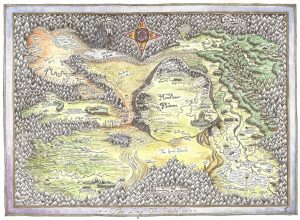
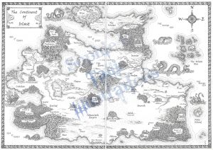
from White Mountain by Sophie E Tallis
How would you say you strike a balance between the need for cartographic accuracy to illustrate the story, whilst also generating an image that is itself a piece of art?
Well, I think first it helps to be a geography nut. I must have well over a hundred maps and atlases at home. If you have a good understanding of not only cartography but of the geography and underlying geology at work within natural landscapes, then it means, no matter how fantastical the project, your work will look realistic and plausible because that real world knowledge of how river and mountain systems work etc., informs your choices and gives your artwork a grounding in realism. For me, the best maps have that wonderful balance of something imaginary and fantastical but also real enough that you feel you could walk in that landscape, cross those fords, hike those hills.
For instance, for one map the author wanted hills but not ‘normal hills’, something unique, so that’s where your cartographic & real world knowledge can kick in. I ended up showing them the strange limestone formations of the Karst Mountains of China. They loved them, so that’s what I produced for a section of their map. The natural world can so often give inspiration for the fantastical.
Where you can also let your imagination run wild is often in the little extra touches, creating sea, land or sky monsters, adding that personal compass, that unique border.
Over the years are there any map designs which you’ve worked on that stand out as your most favourite? Or have there been any which have been the most difficult?
I try not to have favourites as I want to give every project an equal amount of effort and enthusiasm and I’ve worked with some amazing authors! If I had to choose, I suppose I’d have to say the one I did for Anna Smith-Spark’s ‘Empires of Dust’ as it was my very first map for HarperCollins and because of that one map, which was sold around the world, my reputation was established and it lead to a lot of other work and to other major publishers seeking me out.
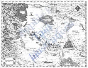
From The Court of Broken Knives by Anna Smith-Spark
Do you have a favourite map which you didn’t draw?
I’m a Tolkien geek, so I love Tolkien’s original maps and their naivety too, which is utterly charming and in keeping with the culture of that work. But for me, some of the most beautiful and intricate maps I’ve seen have been by former Children’s Laureate, illustrator extraordinaire Chris Riddell, whose work is all hand drawn and painted like mine but who has created breath-taking maps for the Edge Chronicles series that simple defy belief!
Lastly, who has been the most fun author, or publisher you’ve worked with?
Apart from my own amazing BFS award winning publishers, Grimbold Books, HarperCollins are great publishers to work for and all of the editors and art directors I’ve worked with so far have been excellent. As for authors, that’s so difficult as they’ve all been so so lovely, so I’ll name the three I’m probably best known for doing maps for, Juliet McKenna, Anna Smith-Spark and Anna Stephens. <3
Thank you so much for joining us!
Thank you, it’s been great fun!
from Godblind by Anna Stephens